This short article is part of our '20 high impact research stories' series. This has been assembled to mark two decades of the City Futures Research Centre 2005-2025. Each of the 20 stories revisits an influential research study completed over those 20 years, linking it with related Centre projects and outcomes. A brochure version of all 20 stories will be published later in 2025.
Over the past two decades, CFRC researchers have played a leading role in redefining how social disadvantage is understood in Australia’s urban environments. Through a landmark series of studies led by Prof Bill Randolph and CFRC colleagues, the Centre has highlighted the changing spatial dimensions of poverty and inequality.
The suburbanising geography of poverty
Foundational to this sequence was Prof Bill Randolph’s influential 2005 study that coined the now widely-used term ‘the suburbanisation of disadvantage’. This research, subsequently updated in a well-cited 2016 journal article and in 2017 and 2020 book chapters, marked a turning point in recognising how structural inequality is reshaping the socio-spatial fabric of Australian cities. Using census data spanning 30 years (1986–2016), the research revealed a profound shift: poverty, once concentrated in inner urban areas, has been pushed out into the middle and outer suburbs of our major cities.

This process, mirroring trends seen in the US and UK, has been driven by a combination of housing market pressures and urban renewal focused on central areas. As Randolph notes, this “great inversion” has created new zones of social and economic exclusion in suburbia, where disadvantaged populations are distanced from jobs, services, and opportunities, while economic activity and housing investment have, if anything, re-concentrated in the inner city.
This work has placed geography at the centre of debates on inequality and on policy. It informed subsequent CFRC research and policy dialogues that stressed the urgent need to integrate social equity into metropolitan planning. Randolph’s findings challenge the dominant narrative of productivity-focused urban intensification, arguing that neglecting suburban disadvantage threatens long-term urban cohesion and efficiency.
Investigating the anatomy of concentrated disadvantage
Building on this foundation, Prof Hal Pawson led a major AHURI research program ‘Addressing concentrations of disadvantage in urban Australia’ (2011-15). Key conclusions from this program included the observation that disadvantaged places in Sydney, Melbourne and Brisbane encompass significant diversity, with such localities separable into four socio-economically distinct types. The increased clustering of disadvantaged neighbourhoods evident in the 2006–11 period extended a tendency ongoing since the 1980s and compounded other evidence of growing economic marginalisation of lower status suburbs in Australia’s major cities.
The evolving geography of disadvantage in urban Australia during the 2000s and early 2010s was identified as largely reflecting the outcome of polarising market forces, virtually unmitigated by countervailing policy intervention. However, as also quantified by the research, the spatial distribution of housing-related government expenditure is profoundly regressive—proportionately far greater ‘housing subsidies’ flow to advantaged postcodes than to disadvantaged postcodes.
Measuring the geography of rental vulnerability
This body of work was more recently extended through the development of the Rental Vulnerability Index. Initially developed by CFRC researchers Dr Chris Martin and Dr Laurence Troy in projects for Tenants Queensland and then the Tenants’ Union of NSW, the methodology is now at the centre of national project, Rental Vulnerability in Australia, funded by the ARC and involving peak tenant organisations across the country. Calculated with reference to ABS census and other data, the RVI quantifies the vulnerability of local renters to housing problems, whether in terms of unaffordability, insecurity, or inappropriateness. That is, conditions that point to the need for tenant advice and advocacy services.
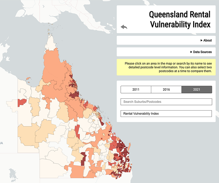
These indices have become valuable tools for policymakers and service providers, enabling targeted interventions to assist vulnerable renters and guide resource allocation. As Tenants Queensland commented on the earlier version of the index developed for their state:
"Queensland Rental Vulnerability Index has been a key tool in planning the services provided by the new Queensland Statewide Tenant Advice and Referral Service (QSTARS) network. QSTARS partners use the RVI to tailor their community education and outreach resources according to the most prevalent vulnerability factors in their areas.
As a state-wide organisation, we have made great use of the RVI’s insights into the distribution of rental vulnerability across Queensland in our representation of tenants’ interests to government – in fact, the Housing Minister has asked us ‘what does the RVI say?’ in consultations on the government’s housing strategy."
Together, these research projects have substantially deepened Australia’s understanding of the geography of disadvantage and informed policy discussions about equitable urban development, targeted service provision, and tenant protections.